Wind in Dakhla: How It Forms—Explained Simply
The wind in Dakhla is not a local phenomenon, but rather the interplay of four mechanisms that reinforce one another. In this order:
1. The Azores High—the driving force
A subtropical high-pressure system lies over the North Atlantic year-round. Air flows out of a high-pressure system in a clockwise direction, so along its eastern flank—which is exactly where the Moroccan-Saharan Atlantic coast lies—there is a steady current flowing from the north to the northeast toward the south. This is the northeast trade wind. It is the underlying current upon which everything else is built.
2. The Saharan Low—the Suction
The Sahara heats up extremely in the summer. Warm air expands and rises, creating a thermal low at the surface. This creates a strong pressure gradient between the high-pressure system over the cool ocean and the low-pressure system over the scorching desert—and wind is nothing more than air equalizing a pressure gradient. The greater the contrast, the stronger the wind.
3. The Canary Current—the Lid
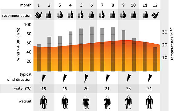
Off the coast flows the cold Canary Current, intensified by upwelling: the north wind pushes surface water away from the land, and cold deep water rises to replace it. The sea off Dakhla is therefore noticeably cold (neoprene wetsuits are needed even in summer). Two consequences:
- The temperature contrast between land and sea becomes even greater, and the pressure gradient even stronger.
- A very stable, flat layer of air forms above the cold water, with a sharp inversion layer above it—a kind of invisible lid at an altitude of a few hundred meters. The airflow cannot escape upward and is forced into this thin layer. The same volume of air passing through a smaller cross-section means higher speed. Meteorologists call this a coastal low-level jet.
That is the real reason why the coast between Essaouira and Dakhla is so reliably strong—and why the wind is so smooth and free of gusts. Stable stratification suppresses vertical mixing, and without mixing, there are no harsh gusts. That’s exactly what makes this spot so pleasant for beginners.
4. Coastline and Sea Breeze—The Fine-Tuning
Two local effects come into play:
- Cape effect: Where the coast forms a protruding headland, the capped current accelerates further (physically similar to a jet). The Dakhla peninsula lies within such an acceleration zone.
Sea breeze: During the day, the desert heats up faster than the cold water, and the rising air from the land draws in sea air. This thermal component adds to the trade winds—hence the typical daily pattern: calm in the morning, building from late morning onward, peaking in the afternoon, and subsiding in the evening.
Why the lagoon benefits so much from this
The peninsula runs roughly NNE–SSW; the lagoon lies in its lee—protected from the waves, but not from the wind. The northeast wind blows flat across the low, smooth spit of land and reaches the lagoon almost unimpeded, while the Atlantic swell remains outside. The result: strong, steady sideshore/side-onshore wind over calm, flat water—strong winds without chaotic waves. This combination is the reason why a kitesurfing center makes sense there of all places, and not 20 km further north.
Dakhla is a real wind sensation and provides us with fantastic wind all year round! The trade winds that migrate between the Canary Islands and Cape Verde in summer and winter hit Dakhla all year round, so the wind blows constantly here on 320 days with approx. 15-22 knots. Coming from the northeast, the wind blows sideshore from the right and is further intensified by the mountains in the hinterland, as the wind is forced through them like a funnel.
The climate is pleasant, with a soothing Atlantic influence, rather dry and not too hot.
The lagoon, which is around 40 km long and 4 km wide, was formed by the Dakhla Peninsula and is connected to the Atlantic Ocean. This means that the water in the lagoon is also affected by the tides:
At high tide, you have a standing area up to 300 m wide around the lagoon.
At low tide, this strip shrinks slightly, but can still be used thanks to 1 km of windward freedom. The ground is covered in fine sand. We still recommend neoprene shoes, as there are shell fragments hidden in the sand in some places. At low tide, this area is partially dry and you only have to walk a few meters further to the water's edge.